Updated 1/4 11:15p
Really not a long post tonight, I'm exuasted still
not smoking 3 days strong, but my body is all wacked out still, I'm gonna stay up to watch the 00z runs of the GFS as my thinking
is it will begin to fall in line with my thinking as I said there is no shock that the models look like crap once out past
mid week... The nature of the pattern change is just too much for them to grasp completely... Only reason I'm staying up is
cause my feeling is the trough coming next week tue-thur is going to be stronger than advertised and sure enough it looked
stronger today than yesterday, and maybe we'll see some flurries too with the clipper coming through... too early to tell
but it is possible... I do think it will be colder than expected and will finally break our streak of above avg temps
its also the tip of an iceburg as to the pattern change coming just a few days later
Before that we're going to deal with warm purhaps
record breaking warm on Sat. with a rainstorm coming on up the coast...
But maybe it won't be that once you look at 00z
(just out you can see it does not look that bad) But still would be quite warm...
Regurdless of whether the storm would be strong
or weak I hope its the last bit of extreme warmth we'll have to deal with for a while AS the bigger rainmaker looks to be
monday and then we get a chages in pieces...
It will warm after the brief cold shot but the
"real deal" is forming for what I think could be a complete pattern flip as I've outlined in posts for the past few days...
And of course we know that even super warmth can
lead to good things...
(FROM LAST WINTER)
This then turned around (this year this could happen
2 weeks earlier)
and we got this...
___________________________________________________________________
Updated 1/3 10:00pm
Not a very long update tonight I do appologize
for not posting yesterday I wasn't feeling to well as for the first time in 6 years I'm not smoking a cigarette, my body
tho is mega shock and yesterday was just ugly... So I hope you understand... Now enough about my stupid problems and
on to the weather... Some were confused about my cross section of the arctic ocsilation, below in earlier posts... so I highlighted
what I meant by the warmth reaching the surface and what happens to the AO by it going negative... left goes back in
time and the scale of the AO can be seen below for the coresponding time frame with AO stauts and the temps there... the top
scale is the atmosphere top ofit is higher up the bottom is the surface, Now we see all the cold at the surface and see how
possitive the AO has been. Now in the top right hand coner we can see that there was some warming in the upper atmosphere...
The black line is the zero annomoly, now when the the black line is going up its getting colder and you can see that that
was happening but in the most recent time frame that line has turned back around so its warming again and coming down
(it has a long way to go)... what cannot be seen is the fact that there is slight yellow up there too (the image isn't fine
enough to see but its there)... so its interesting to see if the warming continues and the AO will drop as its forecasted
to...

Now I know for those rooting for the change to
cold and snowy today was a bit depressing when the EURO came out and wasn't showing things as well as we would like to see
them... But the pattern the EURO is showing is 1) a common model bias and 2) Pattern Change creates problems as well...
The GFS's backing of the trough to far west has been documented but don't be surprised to see the GFS starting to come around
to reality soon... The other indicies are going right where we want to see them...
Now the NAO may be best represented for a bit when
the PAC JET quits for a bit we'll see what the ensembles say then but the image below of where this pattern could go is looking
pretty good for a possible great close to January... As a nice pattern could set and has the potenial to lock if everything
lines up just right
So as the cold really does come down into Canada
and with the reminents of a mild pattern there could be fireworks... Time will tell but things are looking a heck of alot
better and it is possible for us to see a great turn around like the ones seen in 57-58 and 65-66...
What could happen this time ???
___________________________________________________________________
Updated 1/1 8:30pm
Wow two posts in one day... I just wanted to come
back and show a lil more about where we are now and where we are going... Cause the models really are showing us that a change
is definetly coming the question is does the cold come and lock or does it just move out... Thats where the NAO being negative
will come into play and we won't know which way thats going to go until we get closer... before the ensembles were showing
negative then netral now they show possitive... I think the models tho will have problems until we get closer... the key to
this whole change is the AO going negative but more importantly the EPO going negative to start the whole procces... First
a look at where we are now...
****IMAGE BELOW SHOULD SAY TROUGH EAST OF CASPIAN****
Its obvious to see this is a horrible problem...
But look where we should be 8-10 days from now... this is just as the change will start... on the left you will see the EURO
on the right the GFS's interpretation of events, the EURO is showing a much better solution in terms if cold for the east....
The GFS on the other hand has a feedback issue with dumping troughs into the western US (SO THIS SHOULD NOT BE TRUSTED)...
Regardless both models show the easing of the screaming Pacfic Jet. And both show the ridge going up east of the Caspian
and both have broad based trough going into Japan (not highlghted on maps) The EURO tho shows the split in the polar
vortex (which is key to get the arctic vortex to come down) and it better shows the the - EPO which is also the main key...
_____________________________________________________________________
UPDATED 01/01 1:45pm
Happy New Year Everyone, Sorry no post yesterday
was quite busy again, todays will be bfief as well... First I just about want to cry, this current pattern blows and for as
much as I hold out hope for a solid ending to winter (and I still do feel that way)... It really is beginning to take its
toll on me at this point in the season to not have seen any snow... And its becoming more apparent that there will not be
any snow until this pattern chnages... Now I do also want to say that the Teleconection indices really don't look so well...
Especially the NAO ensembles you may remmeber a post about a month back where I took a look at year like this and most had
above avg snowfall, but there was one year that had 0... thats right NO snowfall (71-72') in that post I showed just how important
the NAO being negative is... right now it looks like it will stay possitive for a while... this will be watched and like I
said it is possible the models won't be very consistant. But the PNA is looking to go possitive and the AO still looks
to be going downtown (some days it looks to dive, others its stepping down).... THE RESULT IS STILL THE SAME... Now lets hope
this map is the worst month we have to look back on for this past winter...

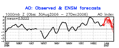
One of the things I've been looking at is the continued
warming of the atmosphere in the arctic... 10 MB level...
now we do have warming in the upper part of the
atmosphere in the arctic as seen in the top right hand corner of the image below, you will see that once that warmth gets
to a lower level that the AO will go negative as seen back in OCT especially... 2 weeks ago it was cold through and through,
now there are changes and the in the animation above you can see how thats happening as well...
Now until that AO turns around expect more of the
same as we will see it again this week...
Hopefully we see these changes soon so we can back
to the way that things used to be...
_____________________________________________________________________
Updated 12/30 12:30pm
Today I'm going to show you the 4 things that have
basically put the brakes on winter.... And in reality the problem can be traced back to one thing it just makes the other
3 things happen... Before I get into that I did wnat t o mention just as I had suspected the teleconection inicies don't look
as good as they did for the past two days...
Altho the PNA does look a bit better than it has
the NAO as you can see is no longer forecatsed to go negative it goes to neutral or just possitive there of... But in the
remaining teleconection the EPO we're looking real good an in reality this might just be key to get this winter rolling....
________________________________________________________________________
UPDATED 12/28 10:02pm
As said before I wanted to post some images tonight
of things that are starting to change, It is true that we will be staring another warm-up (ie blowtorch) in the face
next week... but after that things start to look a little better as the teleconection indicies we like to look at are heading
in direction we like to see for sustained cold and snow... these indicies can be seen below...

Now one thing I do want to be clear on is the dates
here are NOT set in stone, so don't be surprised to see some changes, but I think what we can take from this is that the models
are showing us where we want to go and where we do end up... Now it must be said as I said this morning, things are not
looking good for my snowfall numbers for this season and especially the temp's... Time is starting to run short, but
I do think the snowfall numbers still have a shot remember they are 125-150% of avg, closer to 150 once south of Philly...
so for Berks its 38-44"... A big storm will be needed to get us back in the game here... Now a big storm was always looked
upon as being likely for this winter even before it started, but one thing this pattern has shown me is it likes to snow where
it was once warm... Look at Denver which up until just recently was running warmer for Dec than NYC... The snowstorm in the
midwest was preceeded by very mild temps... I would not be shocked if that is the same situation here once just past our next
mild spell that is coming... Now what we need is a negative NAO... now I know people have complained a bit about the "type"
of - NAO that we may be setting up since its not a "true" - NAO... I don't really care as it will do its dirty work just the
same as apposed to backing in from the east our warmth will slide NE into Canada and actually create the negative NAO and
set up what could be a great blocking pattern... Some call this a mechanically induced negative NAO...


The key for all of this is the AO going negative...
__________________________________________________________
Updated: 12/28 8:32am
Sorry about not posting the past few days, again
I got fairly sick this holiday season and simply put I'm still trying to recover... I will post again this evening with imgaes...
But here is where we are... New Years Storm will happen but of course it will be mild... so more RAIN... Also another blowtorch
is coming... and its time to face some facts as this was not expected its almost time to start to shaving the numbers in regaurds
to snowfall for this winter, or is it ??? Long term the changes in the pattern can begin to be seen... so at this point I
will leave everything alone til we can see if this change is really taking place... But it appears Ridge is going up east
of the Caspian, AO finally will be coming down off of its super high and the NAO will be around Neutral, and further more
a + pna looks to get going, add in a PDO that looks to be going toward negative and one can easily see these are all good
signs for what may come and the time frame for when we'll start to feel these changes looks to be around the 16-21st...
So it appears that the analogs of 57-58 and 65-66 particularly want to let us know that we're still in this... But the clock
is starting to tick... Last time I was in this situation was the winter of 04-05, I was thinking of adjusting the snowfal
numbers downward, but I did not... things got rolling Jan 22-23 with the Blizz of 05' and my snowfall forecast for the season
did verify at 35" which was the bottom of my forecast range. This year my bottom for range is 38" so its becoming obvious
to me that a big storm 15" type will be needed to even have a shot at this... Luckily for me (and you snow lovers) a big storm
has always been in the outlook so at this time things are fine the temps numbers look like they might indeed be a bust tho...
But I never did go extreme on the cold remmeber just 1 degree below...
Time will tell... more later tonight.
_______________________________________________________________
UPDATED 12/24 10:00am
This is my last post for a bit here as I will be
with friends and family the rest of today and into tomorrow... I do hope everyone has a very merry christmas and you will
probably hear from me again on Tuesday...
Now as for the weather not much to mention about
that, that hasn't already been said... My same idea's still apply that its a rain storm that goes to snow once north of Harrisburg...
We MAY see a few flakes at the very end if we get in a burst we get a quick coating, but that will be the exception not the
rule... Pattern will remain mild but active then and I was looking at the New Years time frame for another maybe more wintry
storm... Here is where we stand with the 6Z GFS/DGEX comparison...
So they have backed off a big storm... but the
real question is and has been "cold air??" well I think its finally coming, model runs are starting to look colder further
out... plus the polar votex is finally starting to migrate... below is a link so you can check that out... It has implacations
for us down the road...
____________________________________________________________
UPDATED 12/22 11:00am
Now as I see it my job here is to lay out threats
of whats going in the weather and to point out areas of interest as to when it might snow... Its been a rough pattern as the
threats have not come to fruition but for as depressing as this pattern is one has to remmeber that so far the winter forecast
is going according to plan... And there are bright spots in our (near?) future to finally see winter begin to take back
its rightfull thrown...
First we need to go over what will happen this
Tue I've not been real big on this event ever since it became apparent how mild this pattern would be last weekend, but someone
is going to ge a nice storm... It's obvious to me at this point that we'll have a storm go up the App mts. with redevelopment
on the coast, so the snow threat is west of here mainly Harrisburg and North and West... Now we have a shot at seeing some
white stuff at the end as the 2nd storm takes over but cold air is just not what we need it to be... It will not be
like x-mas 02' well it will, but just a lil too late to give us signifgant snow... But on the horrizon I do see something
to get excited about... and that would be a possible new years storm... the models are all over this of course details are
hard to figure out at this point but bellow you will see yesterdays 18z run of the GFS, today's Candaian, Euro and DGEX all
of which have a decent storm going up the east coast... The Canadian looks the most threatening... Of course a question remains
on "how much cold will be availabe" but it does look promising...