Updated 11/19 9:00pm
RAINSTORM THIS GO AROUND FOR OUR TURKEY DAY...
How ever the emphasis for wet is more north of our area and the Euro run today was even drier...
The Canadian Computer Model is also in the norther camp... with the precip which I buy as this looks like the most likely
scenerio at this point... So instead of a rainstorm, it should just be dreary...
Regurdless Friday's looking to be very cold after the storm passes, thats quite a core of cold at 850 as seen here on
the 18 Z GFS
____________________________________________________________
Updated 11/18 9:30pm
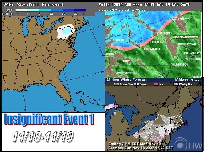
INSIGIFICANT STORM CLASS BUT STILL A FUN LIL BUGGER TO COVER... SNOW CONTINUES BUT LIGHT ORIGINAL CALL LOOKS FINE...
JUST HIGHER AMOUNTS HIGHER UP... ITS A BACKAND FORTH RAIN TO SNOW SNOW TO RAIN GAME FOR BERKS
ADVISORIES UP FOR THE AREA...
SNOW ADVISORY
Issue Date: 600 PM EST SUN NOV 18 2007
Expiration:
500 AM EST MON NOV 19 2007
...SNOW ADVISORY REMAINS IN EFFECT UNTIL 10 AM EST MONDAY...
                                                      A SNOW ADVISORY REMAINS IN EFFECT UNTIL 10 AM EST MONDAY.
                                                      SNOW WILL CONTINUE TO FALL THROUGH TONIGHT, WITH A TOTAL
                                                      ACCUMULATION ON AVERAGE OF 2 TO 4 INCHES. SNOW MAY FALL AT THE
                                                      RATE OF AROUND ONE HALF PER HOUR AT TIMES.
                                                      ROAD SURFACES WILL CONTINUE TO BECOME SLIPPERY, ESPECIALLY
                                                      BRIDGES, OVERPASSES AND LESS TRAVELED ROADWAYS. THIS IS THE FIRST
                                                      WIDESPREAD SNOWFALL OF THE SEASON. IF YOU WILL BE TRAVELING
                                                      AROUND THE REGION TONIGHT, BE PREPARED FOR SLIPPERY CONDITIONS.
                                                      SLOW DOWN WHILE DRIVING AND LEAVE PLENTY OF ROOM BETWEEN YOUR
                                                      VEHICLE AND THE ONE AHEAD OF YOU. THE FALLING SNOW WILL ALSO
                                                      REDUCE THE VISIBILITY.

________________________________________________________________________________________________________
Updated 11/18 4:30pm
GOT TO SEE SOME SNOW... YAY !!! LIGHT BUT NICE TO LOOK AT FOR SURE...
Some pics...
And looking at the latest radar returns and computer models, you can see precip starting to form down near the DC area
if this area of precip does indeed fill in still tonight aditional snow maybe possible and with it being night time accumulations
would be possible.
NWS issues SNOW ADVISORY FOR BERKS
Updated 11/17 4:30pm
TOUGH CALL ON EARLY CLIPPER SNOW... SLIGHT ACCULULATION IS POSSIBLE !!!
As indicted on this site for past two days, clipper system will be coming through and indeed looks to pack a little more
punch than first though, 12z NAM being the most prolific but even the GFS is a lil more juiced up, but is further north with
track as is the RGEM other modes are in the southern NAM camp, which I am in as well due to its more consistant runs...
I like what the MM5 is Doing:
Surface temps not exactly great, best snow can be seen in areas north of line shown below
First and only call...
______________________________________________________________________________________
Updated 11/15 8:31pm
NAM SHOWS YESTERDAY'S IDEA OF LIGHT CLIPPER SYSTEM BRINGING VERY LIGHT SNOW FOR SUNDAY....
_____________________________________________________________
Updated 11/14 8:30pm
BIG RAINSTORM ON THE WAY... USHERS IN NEXT COLD WAVE... LIGHT SNOW FROM CLIPPER POSSIBLE... LATE WEEK STORM GONE... FOR
NOW
Looks like model agreement is pretty good that the best action for rain will be in the interior, but we're on that fence
as shown by both the NAM and the GFS
Could this clipper be a first shot at a lil bit of snow flying arounp, perhaps even a dusting we shall see... Models
are losing next weeks big storm, but at least we have this possible clipper to keep us occupied until the models get their
beaings again....
For sure the cold will be coming...
_______________________________________________________
Updated 11/13 10:14pm
GROWING CONFIDENCE BUILDING FOR A BIG STORM NEXT WEEK...
Here is a look at the model images from the Euro (top) 00z left, 12 z right... both agree on big storms just coastal
vs inland, the GFS on the other hand has begun its usual waffling... with a storm at 00z a big storm at 6z (not shown) and
then nothing on the 12z run... I'm riding the Euro right now there will be a storm just many details yet to be worked out,
We're gone from SNOCON-5 to SNOCON 4 for sure... will bear watching, I will say though to get a decent snowstorm will require
an amzing set of circumstances to go completely right... So odds are against, but this is truly the first threat we'll see
what tonights runs bring in.
____________________________________________________________
Updated 11/12 10:21pm
Just a quick update tonight, it isn't gonna happen but it was pretty to look at on the 12z GFS...
One thing does look interesting in the relm of reality is the kind of cold that we see on the GFS ensembles consistantly,
a cold and possible wild end to the month maybe in store... We shall see...
And I always said if November ends up cold we're in for a blocbuster winter... we have mild air on the way, and this
is where we're at now...
We'll see if the cold at the end of the month can seal our fate... so much is riding on the next couple weeks...
______________________________________________________
Updated 11/7/07 7:45pm
BIG STORM LIKELY... CLOSE CALL... MAYBE
GFS says not so uch but Euro had a big storm cranking up the coast around day 9-10... NAO crashing negative would give
creedance will bare watching...
____________________________________________________________________
Updated 11/7/07 7:30pm
Nothing to see here folks move along, we may pssibly see wome flakes flying around but that is it... Back to my two week
vacation
________________________________________________________________________________
Updated 10/31/07 3:00pm
The astonishing build in snow cover has contiued so much in North America that we are just about at normal levels for
this time of year, compared to how we started the month this was truly an amazing change... Nice Cold a coming...
Pretty good model agreement of our first true cold outbreak at least as show here by the GFS and the EURO
______________________________________________________
Updated 10/22 7:00pm
Hey all just wanted to mention that we have seen
an amazing build up of snowcover in the northern hemisphere with an explosion of snow cover in Siberia in just a few days,
in the days since we've begun to see that start to spill over to North America which is defeinetly a good thing for a snowier
and cold winter... There is alot to overcome this winter to keep it from being mild I'm in teh camp that this can occur due
to the NAO and this buildup of snowcover is further evidence at least for me.
That said we still have a long way to go here are some years
past...
2006
2005
2004
2003
2002
2001
__________________________________________________________________
Updated 10/21 10:00pm
Winter Outlook is up folks, as well as examples now give in
the winter storm classification page and I'm sure you have noticed the reviews of the El Nino Winter of 02-03 and
the La Nina winter of 95-96, the site is almost 100% ready for the winter season now, just need to bring up some more of the
model snowfall maps to the models page and we'll be good to go. Daily updates should begin sometime in Novemeber...
____________________________________________________________
Updated 9/15 10:00pm
Just wanted to add more fuel to teh fire in regurards to winter
research, today looked at La Nina's since 1950 not so much in terms of strength as is usually done but actually more so in
regurds to location (east vs west) that dividing line being longitude 120W... All events were looked with there status
of where thery were based more so in regurds to this line with late summer SST's... Of the events that were a La Nina
West the following winters averaged quite warm
As for east you can see the opposite...
Here you can see 4 eamples of each... starting
with west
and east....
Oh yeah as for where the SST's are based as of
August for this year just east of 120W... and there are other indications for a La Nina east type event...
Just some food for thought...
_____________________________________________________________
Updated 9/11 11:32pm
This year I'm coming out with my winter forecast
a bit earlier than normal (There most likely will be an October update this year however), there seems to be alot of conflicting
information. when looking at the indicies, for example the NAO looks to be negative for this winter (when looking at others
research as well as forecast trends), but when looking at QBO analogs its an absolute nightmare if you like a snowy winter
and this trend of opposites continues through alot of the inicies so I'm mainly going to look at the analogs this year with
the Enso as well as SST analogs as well... first up is the ENSO obviously the biggest player in this coming will be the La
Nina we're heading into, alot of people are debating strength and such, I however like to look at trends in the overall pattern
of the ENSO putting empasis on the exiting ENSO as well, in this I found 4 analogs that work well with the pattern 1903-04,
1906-07, 1966-67 and 1995-96 (all were weak to moderate La Ninas that had quick turn around from moderate el Nino's the previous
winter...

That would look to be a east coast winter lovers
dream in terms of temperatures but not so much in precip when looking at the dry conditions in the SE and Mid Atlantic as
shown, ( a pattern simlar to the one we're in now with the drought)... Factoring in the SST analogs shows a shift in the zones
of cold and wet... My SST analogs look at the northern Pacific and northern Analog they are not seperated here and are just
all thrown together to look for trends... Also when lookint the SST's there are all La Nina winters... from weak to strong...
1906-07, 1908-09, 1916-17, 1942-43, 1954-55, 1964-65, 1973-74, 1988-89, 1995-96, and 2000-01...
Now this shows a more traditional La Nina Look,
the glaring exception though is in the NW US... So in morphing these two together one can See my winter forecast below...
select cities...
Boston -1.2
NYC -1
Philly
-.7
DC -.4
RAL N
ATL +1.3
HOU +2.4
DAL +2
MEM +1.1
STL +1
CHI -1.1
DET -1.4
PIT -.9
MIN
-2
DEN +1
select cities...
Boston 114%
NYC 112%
Philly
110%
DC 95%
RAL 60%
ATL 50%
HOU N/A
DAL N/A
MEM 90%
STL 110%
CHI 140%
DET 120%
PIT 125%
MIN
125%
DEN 100%
Common Storm Tracks this winter... I will be looking for redevelopments
________________________________________________________________________
Updated 9/6 2:30pm
And away we go its September and that means that things start
getting heated up on this website, Winter Outlook research has begun and looks to be on track for a release during the 1st
week of October, no hints or previews this year, but there will actually be an update in November probably 1st week or 2nd
just to tweak the winter outlook as by then things will have more or less settled into the probably patterns...
If you haven't been on the site all summer you will see a number
of changes 1) New graphics all over the place (more are still to be added as well) 2) A Case study of the top 10 (12) winter
storms for Berks County was released, also the radar and satellite pages have been re-done, and that huge mess on the "models"
page is being worked through, if you do go that page scroll down past the dashed lines to see what the format will be for
it this winter...
Updates on this page will be fairly sparce as things of
course are very early, I'm only updating today to give an ouline of whats been going on here and also cause I'm home from
work recovering from the flu and what a flu it was... The were right summer time is definetly the worst flu... feel like 10
MACK trucks have hit me... anyway check out the changes to the site and if you have any questions hit me up on the contact
page.