|
|
 |
|
December 8th - 9th 2005
A very quick moving winter storm affected Eastern Pennsylvania
during the first half of the day on December 9th. Snow began falling between 1 a.m. and 3 a.m. EST and fell heavy at times
between 4 a.m. and 8 a.m. EST. In and close to Philadelphia, freezing rain mixed in with the snow from 7 a.m. EST until the
precipitation ended around 10 a.m. EST. Precipitation went back to snow during heavier precipitation bursts. All precipitation
ended across Eastern Pennsylvania between 9 a.m. and 11 a.m. EST. Snowfall accumulations ranged from around three inches in
the local Philadelphia area to around 12 inches in the Poconos. Ice accretions around Philadelphia averaged around one-quarter
of an inch.

Specific accumulations included in Berks County 9.5 inches
in Stony Run, 8.5 inches in Fleetwood and 8.0 inches in Reading; in Bucks County 9.5 inches in Springtown, 8.0 inches in New
Hope and 6.5 inches in Perkasie; in Carbon County 12.0 inches in Albrightsville, 11.6 inches in Lehighton and 11.0 inches
in Weatherly; in Chester County 9.0 inches in Coatesville and Downingtown, 7.5 inches in Glenmoore and 6.0 inches in West
Chester; in Delaware County 3.8 inches in Chadds Ford and 3.5 inches in Havertown; in Lehigh County 10.5 inches in Alburtis,
9.1 inches at the Lehigh Valley International Airport, 8.3 inches within Allentown, 8.0 inches in Whitehall Township and 7.8
inches in Macungie; in Monroe County 14.0 inches in Pocono Summit, 12.0 inches in East Stroudsburg and 11.0 inches in Saylorsburg;
in Montgomery County 7.8 inches in Trappe, 7.0 inches in Palm, 5.8 inches in King of Prussia and 4.0 inches in Wynnewood;
in Northampton County 10.0 inches in Forks Township, 9.0 inches in Easton and 8.3 inches in Bethlehem and in Philadelphia
3.5 inches in Roxborough, 2.9 inches at Holme Circle and 2.2 inches at Philadelphia International Airport.
Click Here For Radar Loop of Storm
The winter storm was caused by the combination of a vigorous
upper low from the Midwest and a Gulf of Mexico connection of moisture and low pressure systems. Two low pressure systems
formed, one in response to the upper system in the Ohio Valley and one in the northeast Gulf of Mexico on Thursday the 8th.
On Friday morning the 9th, the Ohio Valley low pressure system moved into the Great Lakes and the Gulf of Mexico low pressure
system moved northeast to the North Carolina coast. A third low pressure system formed in response to the strong upper level
support on the Delmarva Peninsula. The low pressure system along the Delmarva Peninsula became the primary low as both the
Great Lakes and North Carolina Coast lows weakened. The Delmarva low pressure system rapidly intensified during the day on
Friday the 9th. It went from 1009 millibars just west of the Long Island Buoy at 10 a.m. EST on the 9th, to a 996 mb low just
south of Rhode Island at 1 p.m. EST on the 9th to about a 988 mb low between Masachusetts and Nova Scotia at 7 p.m. EST. At
7 a.m. EST on Saturday the 10th, the low was at least 979 mb just south of Newfoundland. In 24 hours the low deepened by about
36 millibars. In spite of its quick movement and the late intensification, heavy snow still fell across most of Eastern Pennsylvania.

|
|
|
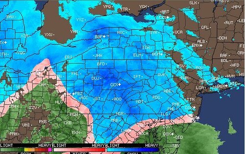
December 15th 2006
A strong warm front associated with a low pressure system
from the Gulf of Mexico caused a protracted precipitation event to occur in Pennsylvania. This was complicated by a very cold
air mass that was in place over the state at the start.
Some record breaking low temperatures occurred just the
morning before. Snow overspread the region between 1 p.m. EST and 3 p.m. EST.
The warm air had an easier time advancing aloft than near
the ground as an unseasonably cold air mass was still in place. The snow changed to freezing rain about an hour after precipitation
started around Philadelphia (4 p.m. EST). It took a bit longer elsewhere changing to freezing rain around 6 p.m. EST in the
Philadelphia northwestern suburbs and Berks County, 7 p.m. EST in the Lehigh Valley and 8 p.m. EST in the Poconos north. Snowfall
accumulations were an inch or less, except in the Poconos where up to three inches accumulated.
|
|
|
|
|
|
|
|
|
|
|
|
February 11th- 12th 2006

A major winter storm affected the northeastern United States,
including the northern mid Atlantic region, during Saturday February 11th and Sunday February 12th. An area of low pressure
developed along the Gulf Coast states on Friday February 10th, and began moving to the northeast toward the North Carolina
coast during February 11th. Snow overspread the region around 11 AM EST on Saturday from south to north. The precipitation
initially was relatively light with temperatures either at or above freezing. The snow really increased in intensity across
eastern Pennsylvania around Midnight EST on Sunday the 12th and around 2 AM EST in the Philadelphia Metropolitan area. The
snow gradually ended from southwest to northeast around Noon EST on the 12th. The snow fell steadily and became heavy at times
in many areas late Saturday night and Sunday morning. The last strong band of snow passed through during the mid morning hours
on Sunday. During this strengthening storm, a good portion of the region experienced intense snowfall rates of 2 to 4 inches
per hour. These intense snowfall rates mainly occurred during Sunday morning the 12th as the storm really intensified off
the Delaware and southeast New Jersey Coasts. During the height of the storm on Sunday morning the 12th, thunder and lightning
occurred as the snow fell. The presence of this thundersnow just goes to show how energetic this storm became. Also, winds
gusted to about 40 mph. The gusty winds, coupled with the falling and accumulated snow, produced near whiteout conditions
along with drifting snow across a good portion of the area. The storm moved away from the region on Sunday afternoon the 12th,
allowing the accumulating snow to come to an end.

Some specific snowfall amounts include, 20.5 inches in
West Caln Township (Chester County), 18.0 inches in Honey Brook (Chester County), 17.5 inches in Quakertown (Bucks County),
17.0 inches in Drexel Hill (Delaware County), 17 inches in Ambler (Montgomery County), 16.5 inches in Royersford (Montgomery
County), 16.0 inches in Exton (Chester County), 16.0 inches in Williams Township (Northampton County), 16.0 inches in Roxborough
(Philadelphia County), 15.2 inches at the Lehigh Valley International Airport (Lehigh County), 15.0 inches in Aston (Delaware
County), 15.0 inches in Lansdale (Montgomery County), 14 inches in Fricks (Bucks County), 14.0 inches in Alburtis (Lehigh
County), 13.0 inches in Doylestown (Bucks County), 12.5 inches in Center City Philadelphia (Philadelphia County), 12.0 inches
at the Philadelphia International Airport (Philadelphia County), 12.0 inches in Boyertown (Berks County), 12.0 inches in Hanover
Township (Northampton County), 11.2 inches in Reading (Berks County), 8.0 inches in Stroudsburg (Monroe County), 6.5 inches
in Germansville (Lehigh County), and 4.0 inches in Pocono Summit (Monroe County).

Click Here For Radar of Storm
|
|
|
|